The Sept. 11, 2012, attack on the U.S. Consulate in Benghazi, Libya reinforced the need for U.S. Army Africa to have at its fingertips the ability to draw upon the most up-to-date detailed maps and imagery of any given region at a moment’s notice.
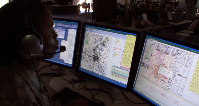
Project Manager Mission Command, or PM MC, is helping to streamline the delivery of maps and imagery through the use of specialized geospatial products that work with the Army’s primary mission command information system, known as Command Post of the Future, known as CPOF.
Although CPOF users have an initial set of digital maps at their disposal, there is usually not enough storage space to keep the latest and most detailed maps for every contingency across the globe. For combatant commands such as U.S. Army Africa, or USARAF, which covers most of the African continent, sometimes the need arises where they must request customized map sets.
Within days of the flare-up in Libya, PM MC coordinated the creation and installation of a specialized map set providing the most recent imagery and detailed maps of that area in support of USARAF.
“When the incident happened we identified the need and got the maps out to them,” said Lt. Col. Tom Bentzel, the Army’s product manager for Tactical Mission Command, or PdM TMC, part of PM MC. “We recognize there’s use for both broad map coverage and detailed map imagery of specific areas of interest. When a new area of interest emerged in Libya, we were able to build a CPOF map set to cover it.”
The maps sent were of several countries in northern Africa, including Libya, and offered sub-meter imagery that was orthorectified to allow for terrain displacement.
“The maps are used on the Soldiers’ CPOF systems to plan, fight and coordinate the common operating picture,” said Matthew Tessier, map manager for PdM TMC and who developed the map sets in response to the flare up in Libya. “Without this technology and the accuracy of it, we could be putting our fighting forces in harm’s way. Getting them the most up-to-date maps for their mission was and is essential to saving lives.”
To continue supplying detailed map data sets in shorter turnaround times, PM MC, assigned to the Program Executive Office for Command, Control and Communications-Tactical, is building an expanded map library. So when conflicts arise, like the recent situation at the Amenas gas plant in Algeria or the clash in Mali, USARAF has detailed imagery if needed.
Tessier works closely with the Army’s Geospatial Center and the National Geospatial-Intelligence Agency to gather map data, then using specialized software converts it for CPOF users.
CPOF allows units to plot real-time operations like firefights on a three-dimensional map, and instantly see updates.
A recent switch by PdM TMC from proprietary software to a commercial mapping capability for the CPOF system has allowed more options when it comes to the data resources used to pull together maps and imagery. For example, PdM TMC can now take an online, commercially available map of a building or site of interest, such as a university or office complex, and combine it with existing military map sets.
“We switched over to commercial software that allows us to be more flexible with raw data,” said Tessier. “We can now gather different types of data available either through military channels or civilian, and have the flexibility to incorporate that onto our map sets.”
PdM TMC is also working with Army terrain teams within USARAF to equip them with the same ability to build maps based upon their tactical needs, significantly shortening the amount of time needed to convert and ship the map sets.
Leslie Call, a PM MC field service representative with USARAF, said the new technology allows the unit to load five times more data onto each hard drive and equips USARAF geospatial engineers with the ability to quickly convert additional imagery for CPOF as hotspots arise.
“We are effectively cutting out the middle man and giving ownership of the maps where it belongs, with the unit,” said Call. “The unit can accomplish in hours what used to take a week.”
As CPOF continues to evolve, it is embracing the next generation of mission command technology with Command Post Web, a web version of CPOF offering similar capability to users with access to the Army’s tactical network. This will also allow CPOF users to pull feeds from other map-based, mission command systems such as Tactical Ground Reporting, or TIGR, Distributed Common Ground System-Army, known as DCGS-A, and Joint Battle Command — Platform, which is referred to as JBC-P.
“One of our goals is to have the best maps out there,” said Bentzel. “So in addition to deploying our own map servers we’re making it possible to access other map services like DCGS-A and TIGR. Every commander wants great maps because they help visualize the battlefield and make better decisions. The tools we’re building make great maps the norm, not the exception.”


