Thursday, April 9, 2026
  • About us
    • Write for us
    • Disclaimer
    • Terms of use
    • Privacy Policy
  • RSS Feeds
  • Advertise with us
  • Contact us
DefenceTalk
  • Home
  • Defense News
    • Defense & Geopolitics News
    • War Conflicts News
    • Army News
    • Air Force News
    • Navy News
    • Missiles Systems News
    • Nuclear Weapons
    • Defense Technology
    • Cybersecurity News
  • Military Photos
  • Defense Forum
  • Military Videos
  • Military Weapon Systems
    • Weapon Systems
    • Reports
No Result
View All Result
DefenceTalk
No Result
View All Result
Home Defence & Military News Technology News

Geospatial Tools and Services Are Modern Warrior’s Weaponry

by FrostSullivan
October 19, 2012
in Technology News
2 min read
0
geospatial tools

geospatial tools

14
VIEWS

Participants within the U.S. defense geospatial products market have reached a point in which each has established their particular niche. The transformation into a tools and services market has begun, as companies develop applications that can enhance and integrate vast amounts of information on to geographic canvases.

The advent of “big data” (geospatial data so large and complex it becomes difficult to process) is a driving force behind initiatives focused on managing new data formats, such as full motion video, high-definition and 3-D graphics.

New research from Frost & Sullivan finds that Department of Defense (DoD) spending on geospatial products and research is estimated to reach $3.21 billion by 2017. This amount would be significantly higher if classified spending were publicly accessible for reporting.

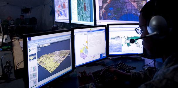
The volume of data being gathered for intelligence, surveillance and reconnaissance (ISR) has become unmanageable. The number of sensors deployed on the ground, unmanned aerial vehicles (UAVs) and satellites continues to soar, as does the ability to keep collection assets in place for longer periods of time. As improvements to systems create the ability to generate even larger volumes of data, U.S. DoD planners are struggling to create methods to ensure that the data collected is useful for warfighters.

“ISR systems supporting operations in Afghanistan are reported to gather over 53 terabytes of data daily,” said Aerospace & Defense Senior Industry Analyst John Hernandez. “This is a significant increase from the start of the war in this country, in which a single terabyte of information was considered a large volume of data.”

In order to meet the challenge of processing and taking advantage of the amounts of geospatial data generated, a mechanism is required that can automatically sort data to the proper users. On the other hand, geospatial data requires exploitation by qualified intelligence analysts that are being inundated with large quantities of raw data. The Defense Advanced Research Projects Agency (DARPA) is developing technologies that will automate and streamline some initial analysis functions to speed up the exploitation process.

The essential value of current imagery, full-motion-video and terrain data continues to generate dependency on geospatial tools and services. In addition to the obvious intelligence value of near-real-time geospatial products and services, the ability to have similar access in the event of national emergencies or natural disasters is invaluable. Geospatial intelligence (GEOINT) can also collect what is sometimes referred to as “nontraditional data.” For example, the amount of cultivated land in a certain area may indicate increased stability. These assets can provide valuable information that provides a better understanding of the adversary and operational environment.

Analysis of U.S. Defense Geospatial Markets is part of the Aerospace & Defense Growth Partnership Services program, which provides global Mega Trends, information on emerging markets and the latest technology innovations, market, economic, customer, competitive, and best practices research.

Tags: ForecastGeospatialintelligenceISRmarketservicessurveillancetools
Previous Post

Northrop Grumman to Build Cyber Test Range in Australia

Next Post

F-35A completes first in-flight JDAM release

Related Posts

US needs top cyber coordinator, better hacker ‘deterrence’

‘Digital fog of war’ around Iranian cyberattacks

March 13, 2026

Hostilities on the digital front have intensified since the outbreak of war between the US, Israel and Iran, with many...

US moves closer to retaliation over hacking as cyber woes grow

Cyberattack Disrupts Operations at MedTech Giant Stryker

March 11, 2026

A cybersecurity incident affecting Stryker Corporation—one of the world’s largest manufacturers of medical devices—has drawn renewed attention to the growing...

Next Post
F-35A completes first in-flight JDAM release

F-35A completes first in-flight JDAM release

Latest Defense News

US needs top cyber coordinator, better hacker ‘deterrence’

‘Digital fog of war’ around Iranian cyberattacks

March 13, 2026
US military says aircraft crash in Iraq killed 4 crew members

US military says aircraft crash in Iraq killed 4 crew members

March 13, 2026
Northrop Grumman moves to boost B-21 Raider output

Northrop Grumman moves to boost B-21 Raider output

March 13, 2026
US Navy evacuates virus-struck aircraft carrier Roosevelt

US military ‘not ready’ to escort tankers through Hormuz Strait

March 12, 2026
Israel cancels leave for combat units after Iran consulate strike

US says Iran campaign cost $11 billion in six days

March 12, 2026
US moves closer to retaliation over hacking as cyber woes grow

Cyberattack Disrupts Operations at MedTech Giant Stryker

March 11, 2026

Defense Forum Discussions

  • Royal New Zealand Navy Discussions and Updates
  • Middle East Defence & Security
  • Royal Canadian Navy Discussions and updates
  • Indonesian Aero News
  • Royal Australian Navy Discussions and Updates 2.0
  • ADF General discussion thread
  • New Zealand Army
  • International Army News Thread
  • Croatian Air Force News and Discussion
  • Chinese J50
DefenceTalk

© 2003-2020 DefenceTalk.com

Navigate Site

  • Defence Forum
  • Military Photos
  • RSS Feeds
  • About us
  • Advertise with us
  • Contact us

Follow Us

No Result
View All Result
  • Home
  • Defense News
    • Defense & Geopolitics News
    • War Conflicts News
    • Army News
    • Air Force News
    • Navy News
    • Missiles Systems News
    • Nuclear Weapons
    • Defense Technology
    • Cybersecurity News
  • Military Photos
  • Defense Forum
  • Military Videos
  • Military Weapon Systems
    • Weapon Systems
    • Reports

© 2003-2020 DefenceTalk.com