I mentioned satellites but I do not know the capability of the A.D.F satellites ,certainly Chinese satellites may have an ability of detection of infrared signatures of stealth aircraft ,tracking a heat signature against a cold ocean via large network of satellites ,this is of course very speculative and I am not qualified
Last fall, Army Gen. James Rainey warned that, “The ability to hide, which is fundamental to how we fight, is now impossible.” That was before China launched Yaogan-41.

www.forbes.com
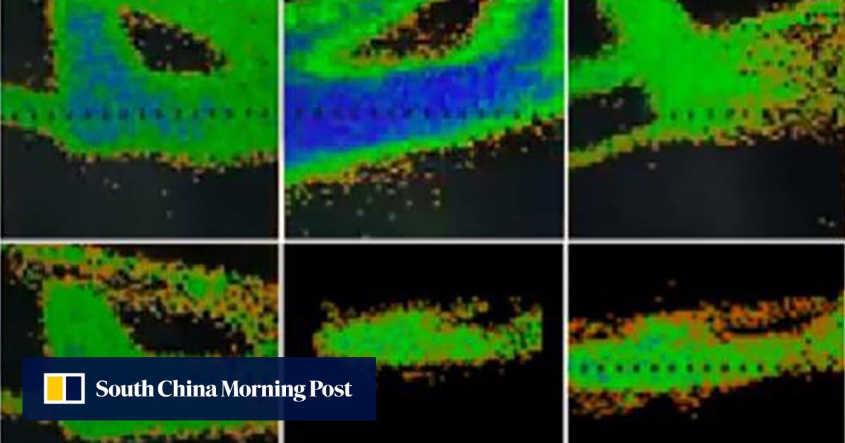
Engineers say their small infrared search-and-track system can pick up the heat signature of a fast-moving aircraft from an unusually long distance.

www.scmp.com
A few points. Generally the term used is LO for Low Observable, not stealth. Unfortunately stealth is something which has been getting used as a buzzword for some time, with some even equating it to specific technologies. I would recommend for those who have not read it, or if it has been some time, re-read
A brief history of LO posted on DT.
One of the reasons why this distinction is important is that, as part of managing the LO properties of an aircraft, this includes managing the infrared or heat signature. This is not just finding ways to reduce the heat signature of a jet engine, but also reducing/distributing the heat generated by friction as air moves across an aircraft's skin as well as other things which could contribute to the heat emitted by an aircraft. Now all of this combined together can firstly make it more difficult to detect the heat signature of an LO object, identify the source of a heat signature if/when detected, and then track a given signature.
Now one of the problems with attempting to provide detection capabilities over a very large area is that there could many potential contacts detected, which in turn could overwhelm the ability of a system or even a network's ability to provide useful information. Take such a hypothetical system monitoring the Pacific Ocean for instance. The heat exhaust from every vessel transiting the Pacific could trigger the system/network as a potential contact, but how much such detections would happen at any given moment? I do not know how many ships or powered boats are normally in the Pacific at any given moment but I would expect the number would be in the thousands. The same would also apply to almost all aerospace aircraft, and this too would likely number at least into the hundreds if not thousands at any given moment. Trying to sort of thousands of active contacts could prove overwhelming when trying to determine which contacts are relevant.
Similarly, what actual level of information do this systems really provide? Could it provide 2D information, or 3D? For satellite systems (and those doing atmospheric bounce) it can make a difference because that could help determine if a detected contact was an aircraft or a surface vessel, or even possibly something else entirely.
Now I could not read the entire article on the IRST but with what I have read, I am somewhat dubious about either the claims or conclusions, not the least of which is because it starts by describing a "heat-sinking radar" when radar uses RF not IR. Further, it does go on to describe elements of an IRST including use of a laser emitter to gather more information, but these systems are really not designed or capable of engaging in volume air searches. Further, the reference distance of ~285 km to detect a civilian aircraft does not mean much, unless such a system were to be used to track/engage military support/transport aircraft which might have comparable signatures. At what range could the system described in the article actually detect an inbound strike aircraft, especially a LO one, or how about inbound standoff ordnance?
So far the articles seem to indicate that China is increasing their respective capabilities, but despite the tone in the articles, nothing strikes me as being particularly different or game-changing.

www.twz.com