Vulcanic Eruption in Java

Ananda

The Bunker Group

This's video of vulcanic eruption from Mt Semeru in East Java today (just around an hour ago). Mt Semeru not only the highest peak mountain in Java, it's also still an active vulcano.


The vulcanic activities increase since Yesterday with increasing tremor and small scale eruption. Today eruption is the largest with significant pyroclastic flow/cloud.
 

ngatimozart

Super Moderator
Staff member
Verified Defense Pro
Any casualties @Ananda You can't out run a pyroclastic flow - they're fast, mean sods. Some can hit 200 - 300 km / hr. There was one from one of the big Lake Taupo eruptions that was calculated to have travelled at supersonic speeds across the ground. Another Lake Taupo eruption produced a lahar that flowed over the top of Ngarahoe and Ruapehu, both volcanic peaks in the central North Island, with a flow rate that was in excess of Mach 1. I would suspect that Mt Toba would be capable of producing similar velocity pyroclastic flows and lahars.

All the joys of living on the Ring of Fire - volcanics, earthquakes, and tsunami. oh and the CCP.
 

Ananda

The Bunker Group
  • Thread Starter Thread Starter
  • #3
@ngatimozart so far no casualties being reported yet. People around Mt. Semeru actually already being warned to prepare evacuation on the last couple of days. However Mt. Semeru it self is a very active vulcanic mountain. Last eruption just happen last year, and people around it already used seeing the mountain have small scale eruption from time to time.

Problem now asside pyroclastic cloud threat, it's also combine with heavy rain (it's rainy season now in Java). This combination can provide flood from all materials being erupted (cold lahar/lava flood).

The local government now focus on evacuation of two subdistrict around the base of the mountain.

Yeah just like you put. Just another joy living in ring of fire area. The area around Mt Semeru located with chain of vulcanic mountain. This make the area, a very fertile agriculture land.
 
Last edited by a moderator:

ngatimozart

Super Moderator
Staff member
Verified Defense Pro
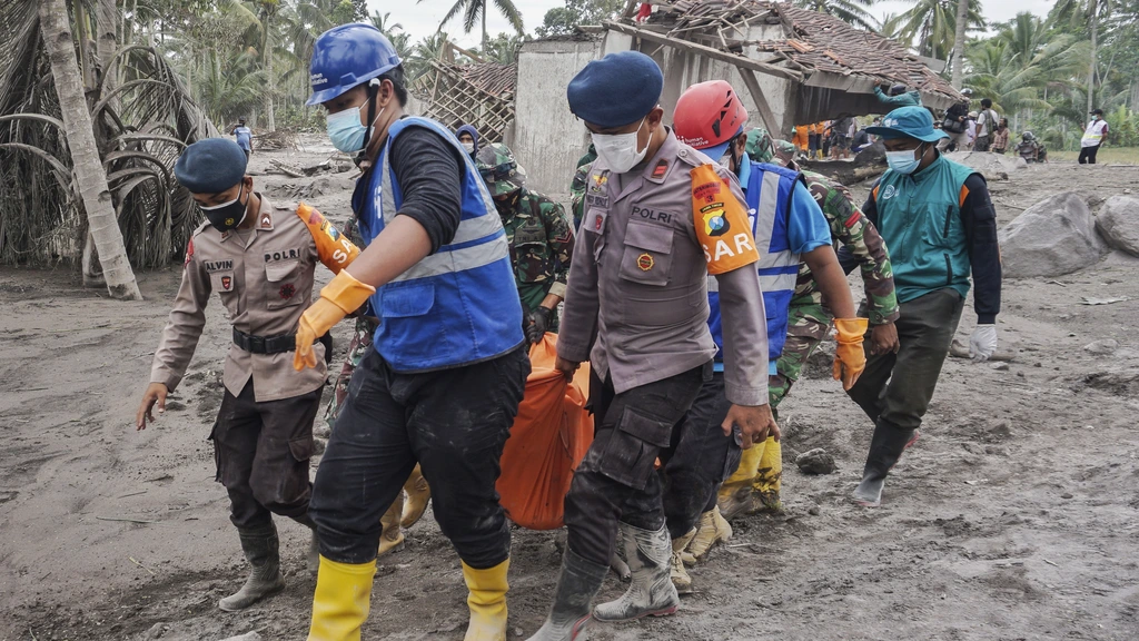
@ngatimozart so far no casualties being reported yet. People around My. Semeru actually already being warned to prepare evacuation on the last couple of days. However Mt. Semeru it self is a very active vulcanic mountain. Last eruption just happen last year, and people around it already used seeing the mountain have small scale eruption from time to time.

Problem now asside pyroclastic cloud threat, it's also combine with heavy rain (it's rainy season now in Java). This combination can provide flood from all materials being erupted (cold lahar/lava flood).

The local government now focus on evacuation of two subdistrict around the base of the mountain.

Yeah just like you put. Just another joy living in ring of fire area. The area around Mt Semeru located with chain of vulcanic mountain. This make the area, a very fertile agriculture land.
That's good that there are no casualties. The volcano is a dangerous bedfellow. If provides such fertile soil that actively encourages human settlement and habitation, but the price it demands for its favours is very high. Always in blood. Well I suppose that it does keep life interesting.
 

Ananda

The Bunker Group
  • Thread Starter Thread Starter
  • #5
This combination can provide flood from all materials being erupted (cold lahar/lava flood).
The cold lahar flood already destroy the bridge that connect the District around Mt Semeru with other area in East Java. This is why actually being concerned more, then the pyroclastic. Heavy rain turn the pyroclastic and vulcanic materials into heavy flood. This kind of flood that can create more casualties.


swerve

Super Moderator
Any casualties @Ananda You can't out run a pyroclastic flow - they're fast, mean sods. Some can hit 200 - 300 km / hr. There was one from one of the big Lake Taupo eruptions that was calculated to have travelled at supersonic speeds across the ground. Another Lake Taupo eruption produced a lahar that flowed over the top of Ngarahoe and Ruapehu, both volcanic peaks in the central North Island, with a flow rate that was in excess of Mach 1. I would suspect that Mt Toba would be capable of producing similar velocity pyroclastic flows and lahars.

All the joys of living on the Ring of Fire - volcanics, earthquakes, and tsunami. oh and the CCP.
Yeah. My mother-in-law is getting lightly shaken at the moment. Lots of small quakes around Fuji. One was big enough for my wife to hear it when she was on the phone to her mother. Hoping they're not precursors to a biggie, or an eruption.
 

Sandhi Yudha

Well-Known Member
Indeed very frightening.

According to the BBC:
"Meanwhile a monitoring body issued a warning to airlines of an ash cloud rising up to 15,000m (50,000 ft)."

So this means also a huge impact on air traffic in that area. Specially traffic flying to Malang (MLG) and Surabaya (SUB).
 
Last edited:

Ananda

The Bunker Group
  • Thread Starter Thread Starter
  • #8
Semeru located in the southern Java air route that also being used for air traffic to Bali. So yes practically it can create air traffic problem to overall east java area, plus to Bali and potential Lombok.

If the vulcanic cloud up to 15K meter or 50k ft, then it can potentially not only impacting air traffic in Southern Java route, but also Northern Route also.

Add:

NOTAM already been send, and as I suspected it is impacting air route to Denpasar, Lombok and Kupang. Basically air route to Bali and Nusa Tenggara Islands has to be diverted to northern route.


This route also being used by Airlines to Australia, so I suspect some Airlines route using South East Asia mainland route to Australia need bit diversion.
 
Last edited:

Ananda

The Bunker Group
  • Thread Starter Thread Starter
  • #9

More video shown the impact on yesterday eruption. So far dozens people got burn treatment and at least one fatality due the burn from pyroclastic cloud. However as the video shown, the impact from cold lahar flood is more worrisome. There're reports of dozens people still missing, around the flood lines.


This geological channel in you tube can provide at least initial assessment in english. As I mentioned before, Mt Semeru actually already in constant volcanic activities since last year. In fact couple years back, when I visit adjacent My Bromo (one of known tourist attraction), we can see the occasional cloud of smoke coming from Mt Semeru.

Thus this series of lower intensities vulcanic eruptions already create some sort of usual pattern for villagers in the foot of the mountain. This despite increase warnings the last couple of days. Yesterday eruption due to sudden disintegrating of Mt Semeru lava dome.

For that, I'm afraid more fatalities can come out within today and next several days. After SAR team can begin combing the impacted area.
 

Ananda

The Bunker Group
  • Thread Starter Thread Starter
  • #11
Lots of small quakes around Fuji. One was big enough for my wife to hear it when she was on the phone to her mother.
Fuji and Semeru shares similarity in size, height, and volcanic type. Both also shares cultural symbolism importance to people in Java and Honshu.

Java and Honshu shares many similarities in term of civilisation development. Vulcanic mountains in both islands provide fertile land and thus enable creating large population central. Few years back I went to visit Fuji and see similarities in term of how fertilities of with land around the vulcanic mountains in Java and Sumatra.

That's where symbolism of vulcano mountains shares within several cultures. Both as live givers and takers.
 
Last edited:

Ananda

The Bunker Group
  • Thread Starter Thread Starter
  • #12

Current calculation is 14 death so far. As predicted most death related to cold lava/lahar flood that engulfed their villages. The pyroclastic cloud reach 11KM, thus engulfed surrounding villages. Plus heavy rains that happen not long after eruption create lahar flood that swept villages along the river banks.

Early warning already been given couple days before big eruption in Saturday. However people including local government already used to see Semeru doing constant small vulcanic eruption. The warning also not put emphasis enough on the potential scale eruption.

Local media inform the Vulcanic Agency seems worry more on Mt Merapi in Central Java, then Mt Semeru. Seems they already calculate there will be eruption from Mt Semeru soon, but not in the scale of Saturday eruption.
 

ngatimozart

Super Moderator
Staff member
Verified Defense Pro

Current calculation is 14 death so far. As predicted most death related to cold lava/lahar flood that engulfed their villages. The pyroclastic cloud reach 11KM, thus engulfed surrounding villages. Plus heavy rains that happen not long after eruption create lahar flood that swept villages along the river banks.

Early warning already been given couple days before big eruption in Saturday. However people including local government already used to see Semeru doing constant small vulcanic eruption. The warning also not put emphasis enough on the potential scale eruption.

Local media inform the Vulcanic Agency seems worry more on Mt Merapi in Central Java, then Mt Semeru. Seems they already calculate there will be eruption from Mt Semeru soon, but not in the scale of Saturday eruption.
I think that the sudden collapse of the lava dome due to the heavy rainfall caught the local authorities out, and maybe some in central government. If it's something that they are unfamiliar with then they may have trouble appreciating the severity of it. I don't know how prevalent this particular phenomena is in the literature, but hopefully it's a lesson learnt.

The real problem with volcanology is that what is known is dwarfed by what is not known. We actually know far more about the solar system, galaxy, and universe than we do about what lies below the surface of the earth, its systems, what and how it works. The same can be said for the world's oceans.
 

Sandhi Yudha

Well-Known Member
34 people lost their lives, 68 get wounded, and 17 people are still missing.


In the link above there is a video of the area around Gunung Semeru after the eruption.
Here a couple of hours before the eruption a person made an impressive video from his drone.

I never expected that such a small drone can reach such distances at those high altitude with that speed. You can skip the first 3:30 minutes.

 
Last edited:

Ananda

The Bunker Group
  • Thread Starter Thread Starter
  • #15

Put this video, asside shown how much the pyroclastic cloud bassically cover this one village that very close with Mt Semeru. Also this video shown clear image on Mt Semeru after eruption. The condition of the mountain, shown significant amount of it's side blown as Pyroclastic cloud and cold lahar flood.
 

Ananda

The Bunker Group
  • Thread Starter Thread Starter
  • #16

Videos from condition during Semeru eruption begin to shown. This one shown by CNN Indonesia quite interesting and bit tragic (in my opinion).

Thanks to Android smart phones, people can shown to the world their visual observation during a disaster struck. This one coming from a Sand Quarry (that at present already completely covered by lahar flood and pyroclastic cloud). Shown the moment initial Pyroclastic cloud approaching the Quarry. Seems they are trying the leave the Quarry, however I don't see them doing it in more urgency.

This's seems collaborate some witness saying the initial Pyroclastic not that big, however the later ones that huge on the sudden (which I put the link on first video in this thread).

The ironic thing, the person who make the video (of initial Pyroclastic cloud in Quarry) still missing. However seems he's able to upload the video.
 
Top